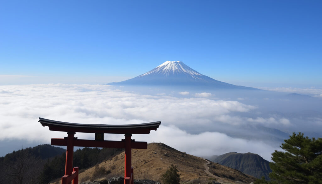
Mt Fuji – Complete Travel Guide & Climbing Tips
Mount Fuji stands as Japan’s tallest peak, an active stratovolcano that has shaped the nation’s landscape and culture for millennia. Located roughly 100 kilometers west of Tokyo, its near-perfect cone is both a global icon and a living geological feature, last erupting in 1707. This guide offers a thorough look at everything from travel logistics and climbing routes to eruption history and visibility from the capital, grounded in verified facts and official sources.
For anyone planning a visit, understanding the mountain’s dual nature—a breathtaking sight and an active volcano under constant surveillance—is essential. Whether you are considering a day trip from Tokyo, a summer ascent, or simply want to know if the mountain will erupt again, the answers lie in the data collected by scientists and the experiences of millions of visitors who have come before.
How Far is Mount Fuji from Tokyo and How to Get There?
Mount Fuji sits on the border of Yamanashi and Shizuoka prefectures, approximately 100 kilometers west of the Tokyo-Yokohama metropolitan area. This proximity makes it one of the most accessible major natural landmarks from the capital, feasible as a straightforward day trip.
Travelers have several options for reaching the mountain. Kawaguchiko, a popular base town in the Fuji Five Lakes region, can be reached from Tokyo in about 90 minutes by car via the Chuo Expressway. Direct highway buses from Tokyo’s Shinjuku station take roughly two hours to the same area, making it a simple, no-transfer journey for most visitors.
- Mount Fuji is Japan’s tallest peak and an iconic symbol, visible from Tokyo on clear days.
- It is an active volcano but has been dormant since 1707; monitoring is continuous.
- Climbing is popular but requires preparation: altitude, weather, and limited season.
- Day trips from Tokyo are feasible via highway bus or train, with many viewpoints and attractions.
- The nearest towns to the mountain include Fujiyoshida, Fujinomiya, and Gotemba.
- On rare, very clear days, Mount Fuji can be seen from as far as Osaka, but this is uncommon.
- A practical day itinerary involves a morning departure, visiting the Fuji Five Lakes area, and returning by evening.
| Fact | Detail |
|---|---|
| Elevation | 3,776 m |
| Location | Yamanashi and Shizuoka prefectures |
| First Ascent | 663 AD (by an anonymous monk, according to legend) |
| Last Eruption | 1707 (Hōei eruption) |
| Volcano Type | Stratovolcano |
| Climbing Season | July 1 – September 10 (main routes) |
| UNESCO Status | World Heritage Site (Cultural, 2013) |
| Distance from Tokyo | Approx. 100 km (straight line) |
| Volcanic Alert Level | Level 1 (normal, as of last available data) |
For travelers who prefer a curated experience, similar destination guides like the Mr and Mrs Smith Hotels – Guide to Curated Boutique Stays offer insights into planning high-quality trips, though Mount Fuji itself is best approached with its own dedicated logistics.
Is Mount Fuji an Active Volcano? What’s the Eruption Risk?
Yes, Mount Fuji is classified as an active stratovolcano. It has been dormant since the Hōei eruption of 1707–1708, but the Japan Meteorological Agency monitors it 24/7, and its alert level is set at normal (Level 1), permitting all regular activities including seasonal climbing.
When was the last eruption of Mount Fuji?
The most recent major eruption was the Hōei eruption, which began in December 1707 and lasted approximately 16 days. It was triggered about 49 days after the Hōei earthquake. Volcanic ash from this event fell as far as Edo, modern-day Tokyo, and the eruption produced the prominent Hōei crater on the mountain’s southeastern flank.
Will Mount Fuji erupt again?
Scientists do not predict the exact timing of the next eruption. Geological summaries note that large eruptions at Fuji may occur on roughly 500-year scales, but this is a broad average, not a forecast. The mountain has erupted more than 15 times since 781 in historical records, with at least 16–17 confirmed eruptions cited in reference sources. Continuous monitoring by the Japan Meteorological Agency remains the primary tool for assessing any changes.
Mount Fuji’s volcanic alert level is maintained at Level 1 (normal) by the Japan Meteorological Agency, meaning no immediate signs of unrest. However, the mountain is under constant surveillance, and any changes would be reported promptly by official channels.
What is the elevation of Mount Fuji?
The elevation of Mount Fuji is 3,776 meters (12,388–12,389 feet), making it the highest mountain in Japan. This measurement is confirmed by GPS and standardized in all official sources.
How High is Mount Fuji and What Makes It Unique?
Mount Fuji’s height of 3,776 meters defines its prominence, but its identity as an active stratovolcano is equally defining. The mountain is an isolated peak exceeding 3,000 meters in elevation, and its conical shape is the result of volcanic activity that began approximately 100,000 years ago.
Its UNESCO World Heritage status, granted in 2013 as a cultural site, recognizes its profound influence on Japanese art, religion, and pilgrimage. Temples and shrines dot its slopes and base, reflecting a spiritual significance that predates modern tourism. For those interested in visitor attractions and logistics, the Fleet Air Arm Museum – Tickets, Hours and Visitor Guide provides a model for how such sites manage access, though Mount Fuji’s natural environment imposes its own unique restrictions.
Can You Climb Mount Fuji? Tips for Hiking and Best Time
Climbing Mount Fuji is a major tourist activity, with roughly 300,000 people making the ascent in a typical year. The main hiking season runs from early July to early September, when trails, mountain huts, and bus services are open. Climbing outside this window is strongly discouraged due to severe cold, high winds, and significant safety risks.
What is the best time to climb Mount Fuji?
The official climbing season is July to early September, with the most popular period being the summer holidays. Weather conditions are most stable during this window, and all facilities operate.
How long does it take to climb Mount Fuji?
The ascent typically takes 5–7 hours from the 5th station to the summit, depending on the route and pace. The descent takes 3–5 hours. Most climbers aim for an overnight schedule to reach the summit for sunrise, known as goraiko.
What are the climbing routes on Mount Fuji?
There are four major routes: Yoshida, Subashiri, Gotemba, and Fujinomiya. Each starts from a different 5th station. The Yoshida route is the most popular. All routes have designated rest huts and are well-marked during the season.
Is climbing Mount Fuji difficult?
The climb is considered demanding but achievable for a fit person. Altitude sickness is a real concern, and the terrain can be steep and rocky. Proper gear, warm clothing, and an early start are essential. The volcano’s alert level remains at Level 1, meaning no volcanic restrictions are in place for climbers.
Check the official climbing website (fujisan-climb.jp) for daily weather and trail conditions. Even in summer, temperatures near the summit can drop below freezing at night, and sudden storms are common. Altitude sickness can affect anyone, so ascending slowly and staying hydrated are key to a safe climb.
Where Can You See Mount Fuji? Best Viewpoints in Tokyo and Beyond
Mount Fuji is visible from Tokyo on clear days, but visibility is not guaranteed. It depends heavily on weather, humidity, haze, and air quality. The best conditions occur on cold, dry, low-humidity days, especially in winter and often in the early morning. Rainy, humid, or smoggy days typically obscure the view entirely.
For travelers, Mount Fuji is a common skyline feature when conditions are favorable, but it should not be relied upon every day. The Fuji Five Lakes area, particularly Kawaguchiko, offers consistent and spectacular close-up views, as do observation points in Hakone. The 1707 eruption demonstrated the mountain’s reach when ash fell as far as Edo (Tokyo), confirming that it sits well within visibility range from the capital.
How reliable is the Mount Fuji visibility forecast?
Visibility is entirely weather-dependent. Real-time webcam images are available through the Japan Meteorological Agency and the official climbing website. Winter months generally provide the clearest skies for viewing from Tokyo.
What Do Visitors Say? Reviews and Dining Options Near Mount Fuji
Visitors consistently praise Mount Fuji for its iconic shape and deep cultural significance. It is described across multiple sources as one of Japan’s most popular tourist attractions and a major international destination for both tourism and mountain climbing. The views from the Tokyo region and the surrounding lakes are highly valued.
As a climb, Mount Fuji is respected but demanding. Safety concerns are highlighted for those attempting ascents outside the official season. Historically and spiritually, the mountain is revered, with temples and shrines around and on the volcano itself.
Are there restaurants on or near Mount Fuji?
Yes, dining options exist, but they are seasonal and limited. Mountain huts along the climbing routes offer basic food and drinks during the summer season. At the base in towns like Kawaguchiko and Fujinomiya, a variety of restaurants serve local specialties such as hōtō noodles. At the summit, small stalls provide warm meals, but availability is restricted to the climbing season. For a broader overview of nearby amenities, planning resources such as destination guides can be helpful, though no curated dining guide is available in this research.
Key Events in Mount Fuji’s History
- ~100,000 years ago: Volcanic activity begins, forming the current cone.
- 663 AD: First recorded ascent by an anonymous monk, according to legend.
- 864 CE (Jōgan eruption): One of the largest historical eruptions; lava flows entered the ancient Lake Senoumi, creating the modern Aokigahara area and splitting the lake into Lake Saiko and Lake Shōji.
- 1707 (Hōei eruption): Last major eruption. Volcanic ash falls on Tokyo. Eruption lasted approximately 16 days and created the Hōei crater.
- 1872: First recorded ascent by a woman, Lady Fanny Parkes.
- 1936: Fuji-Hakone-Izu National Park established.
- 2013: Registered as UNESCO World Heritage site (cultural category).
- 2024: Continued monitoring continues; new climbing regulations enacted to manage crowding and safety.
Established Facts and Unanswered Questions About Mount Fuji
Established Information
- Elevation is 3,776 m (measured by GPS).
- Last eruption occurred in 1707.
- Climbing season is July to early September (official).
- Distance from Tokyo is about 100 km as the crow flies.
- It is an active stratovolcano under continuous monitoring.
Information That Remains Unclear
- Next eruption timing is unknown; scientists monitor but cannot predict precisely.
- Visibility from Tokyo depends on weather; clear days are common in winter but unreliable.
- Climbing conditions (snow, wind) vary daily; check official site before departure.
- Restaurant availability at summit is seasonal and limited.
- Views from locations like Osaka are extremely rare and depend on very clear conditions.
The Cultural and Environmental Context of Mount Fuji
Mount Fuji’s cultural significance extends far beyond its geology. It is a national symbol, a pilgrimage destination, and an endless subject of art and literature. This dual role as both a natural wonder and a cultural icon creates a constant tension between tourism, preservation, and safety.
Recent efforts have focused on limiting overcrowding on climbing trails and reducing the environmental impact of the hundreds of thousands of annual visitors. New climbing regulations were enacted as recently as 2024 to manage these pressures. Compared to other iconic volcanoes like Mount Kilimanjaro or Mount Rainier, Mount Fuji is distinct for its accessibility from a major capital city and its cultural status.
Sources and Credibility
“Standing at 3,776 meters, Mt. Fuji is the tallest peak in Japan, the result of volcanic activity that began approximately 100,000 years ago.”
— Japan National Tourism Organization (japan.travel)
“Mt. Fuji is an isolated peak exceeding 3,000 meters in elevation. While it boasts a breathtakingly beautiful appearance, it also possesses a harsh natural environment.”
— Official Mt. Fuji Climbing Website (fujisan-climb.jp)
“Mount Fuji has erupted about 180 times over the past 5,600 years, most recently in 1707.”
— Wikipedia / Japan Meteorological Agency
These sources form the backbone of the information presented. Additional data comes from the Britannica entry on Mount Fuji, the Wikipedia article, the Tokyo Metropolitan Government’s Fuji ash-information site, the Smithsonian Institution’s Global Volcanism Program, and other reputable outlets. For a deeper dive into Japan’s broader tourism landscape, the Japan National Tourism Organization’s Mt. Fuji guide and the Official Mt. Fuji Climbing Website are authoritative resources. The Japan Meteorological Agency’s volcano warnings page and the UNESCO listing for Mount Fuji offer additional verified data.
Summary: What You Need to Know About Mount Fuji
Mount Fuji is a 3,776-meter active stratovolcano, last erupted in 1707, and is one of the world’s most accessible major peaks from a capital city. For sightseeing, a day trip to the Fuji Five Lakes area is ideal; for climbing, the official summer season is the only safe window. Visibility from Tokyo is possible but weather-dependent, with winter offering the clearest views. The mountain is monitored around the clock, and while the next eruption cannot be predicted, current conditions are at normal levels. It remains a defining feature of Japan’s natural and cultural landscape, drawing hundreds of thousands of visitors each year.
Frequently Asked Questions
What city is Mount Fuji in?
Mount Fuji spans the border between Yamanashi and Shizuoka prefectures. The nearest towns are Fujiyoshida, Fujinomiya, and Gotemba.
Can I see Mount Fuji from Osaka?
On very clear days, Mount Fuji is visible from high points in Osaka, but it is about 250 km away, so visibility is rare. Most visitors view it from Tokyo or the Fuji Five Lakes area.
How reliable is the Mount Fuji visibility forecast?
Visibility is weather-dependent. Websites like the Japan Meteorological Agency provide real-time webcam images. Winter months often have clearer skies.
Are there maps of Mount Fuji available online?
Yes, detailed maps for climbing routes and surrounding areas are available on the official climbing website (fujisan-climb.jp) and in guidebooks.
Is climbing Mount Fuji dangerous?
Climbing is generally safe during the official season with proper preparation. Risks include altitude sickness, cold weather, and sudden storms. Off-season climbing is strongly discouraged.
Can children climb Mount Fuji?
Children can climb, but the ascent is long and demanding. Many families opt for a partial climb from the 5th station. Proper gear and pacing are essential, and altitude sickness can affect anyone.
How much does it cost to climb Mount Fuji?
There is no entrance fee, but bus fares from Tokyo to the 5th station cost around ¥2,000–¥3,000 each way. Mountain hut stays cost ¥5,000–¥10,000 per night, including a meal. A voluntary ¥1,000 conservation donation is encouraged.
What should I bring to climb Mount Fuji?
Essential items include warm clothing, rain gear, sturdy boots, a headlamp, water, snacks, cash, and an emergency blanket. Proper preparation can be the difference between a memorable experience and a dangerous one.
More related posts
 Before the Coffee Gets Cold – Complete Time Travel Guide
 Top 10 Netflix Series – Current Hits, Records and Best Shows
 BBC Weather East Grinstead – Latest Forecast and Snow Alert
 Olivier Richters – Height, Weight, Net Worth and Partner
 Emily Black – Age, Instagram, TikTok & OnlyFans Bio
 Best NMN Supplement UK – Independent Reviews & Expert Guide
 Which Magnesium Is Best for Sleep – Guide to Deeper Rest
 What Language Do They Speak in Belgium – Dutch French German